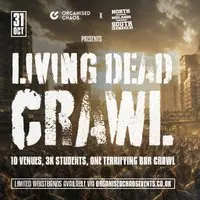
31 October 2026 · 20:00 – 04:00
The Living Dead Crawl – Halloween 31/10/26
All Over Sheffield, Sheffield, S1 4EA
Get ready for The Living Dead Crawl, the infamous Halloween student bar crawl that brings over 4,000 students to the streets of Sheffield.
Getting there and what to expect
Weather
- No forecast yet for this date (Weather data from MET Norway, CC BY 4.0)
- Sunset 16:36, dark from 17:12 (Sunset and dusk computed for the venue)
Getting there
- Stops: Townhead Street/Tenter Street (nr) (193 m); West Street/Carver Street (CH3) (250 m, 6 7A 30 30A X30 51); West Street (Ne Entrance) towards City Centre (253 m) (Stops: NaPTAN, Department for Transport (OGL v3); lines: bustimes.org / Bus Open Data (OGL v3))
- Sheffield Rail Station 1.0 km away, tram at West Street 250 m away (Stops: NaPTAN, Department for Transport (OGL v3); lines: bustimes.org / Bus Open Data (OGL v3))
- Parking: Rockingham Street 180 m, 531 spaces (OpenStreetMap contributors (ODbL))
- Cycle parking 80 m, EV charger 280 m (Carver Lane Charge Point) (OpenStreetMap contributors (ODbL))
- About 6 min walk from the city centre (470 m, straight-line estimate) (Straight-line estimate at 5 km/h; streets are longer)
- Open on the main map with this event pinned (Sheffield Events live map)
- Can I get there and back? Put your postcode into the tool below for the last bus and tram, the walk home, and the car parks. (Timetables: Bus Open Data Service (Department for Transport). Contains public sector information licensed under the Open Government Licence v3.0.)
Around the venue
- Air quality within WHO guideline (PM2.5 4.6, PM10 9.5 µg/m³, sensor 1.7 km away) (Air quality: Sensor.Community (ODbL, indicative) and DEFRA UK-AIR (OGL v3))
- Defibrillator 50 m, toilets 370 m (OpenStreetMap contributors (ODbL))
- No storm overflow discharging within 1 km (Storm overflows: Yorkshire Water (CC BY 4.0))
What is on around it
- Bring It To The Owner: Scarchas Sexy Halloween Party (23:00, 10 m away) (Sheffield Events listings)
- Old Skool Bingo Sat 26th Oct Halloween Sheffield Special (18:00, 170 m away) (Sheffield Events listings)
- Halloween House Party Saturday 31st October sheffield (22:00, 170 m away) (Sheffield Events listings)
Can I get there and back
The last bus and tram, the walk, what is recorded about step-free access and the car parks.
- Nearest defibrillator Defibrillator 50 m away
- Nearest toilets Toilets 370 m away · free
- Nearest cycle parking Cycle parking 80 m away · 8 spaces · University of Sheffield
- Nearest EV charger Carver Lane Charge Point 280 m away · charge to use · Sheffield City Council
Read about this area on Wikipedia
- Turner Museum of Glass
- St Vincent's Church, Sheffield
- St George's Quarter
- Sir Frederick Mappin Building
The Sir Frederick Mappin Building, or more familiarly the Mappin Building, is a Grade II listed building fronting onto Mappin Street, Sheffield, England, part of the University of Sheffield.
- St Vincent's Quarter
Article titles and extracts from Wikipedia, CC BY-SA 4.0; each links to its article.
- 57 to Stocksbridge 6.7 km away
- 195 to Leeds City Centre 13.1 km away
- N13 to Belgravia 27.1 km away
Around the same time
Staying over?
Make a night of it – find a place to stay near All Over Sheffield, Sheffield, S1 4EA.
- Leopold Hotel Sheffield 336 m away
- Cutlers Hotel Sheffield 623 m away
- Mercure Sheffield St Paul’s Hotel and Spa 626 m away
- Premier Inn Sheffield City Centre (Angel Street) 706 m away
- Novotel Sheffield Centre 710 m away
You might also like
Your event memories
Check in, add a photo and build your Sheffield journey.