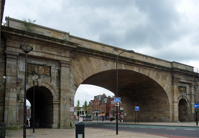
Cover photograph: Wicker Arches in 2012. Photo: Stephen Richards / Geograph, CC BY-SA 2.0.
The Wicker Arches are one of the easiest pieces of Sheffield history to pass without really seeing. They carry a railway viaduct over the Wicker and still make a grand stone gateway between the city centre and the north-east of the city. The bridge was built in 1848 for the Manchester, Sheffield and Lincolnshire Railway. Historic England credits engineer John Fowler and architects Weightman and Hadfield. The trains and the street changed; the arches stayed.
Start underneath
Walk towards the main arch and look at the smaller pedestrian openings on either side. The scale is different when you stand under the stone instead of seeing the bridge from a bus window. The road is busy, so use the proper crossings and pavements; this is a working piece of city, not an empty monument. From the Wicker, the arch frames one set of buildings. From the other side, it frames another. That is a simple way to notice how the bridge divides and connects the neighbourhood at once.
The stonework also has details that are easy to miss at traffic speed. A photograph can show the overall shape, but it cannot give you the sound and distance under the span. Take a moment to look up from a safe place. You are looking at Victorian railway engineering designed to make an arrival in Sheffield feel substantial.
What ran above?
The viaduct led to Sheffield Victoria station, a major railway arrival point that no longer serves passengers. That lost route is why the bridge can feel slightly mysterious now: the structure is obvious, but many people under it are not on a train journey. The Historic England record describes the Wicker viaduct as a listed railway structure built in 1848-49. Old images in Picture Sheffield show how the street, trams and nearby businesses changed around it.
Do not confuse the Wicker Arches with a single isolated bridge. They are part of a longer railway landscape across the Don valley. Understanding that makes a walk towards the river and former station area more rewarding. The railway was an arrival route, a freight route and a force shaping where streets and businesses grew.
A Sheffield street around a landmark
The council’s city-centre neighbourhood framework describes the Wicker as a historic gateway from the north and notes how later roads cut across older connections. That helps explain why the area can be awkward to read on a modern map. A road scheme may make through traffic faster while making a short walk feel longer. The arches remain a clear landmark through those changes.
You can use the bridge as the start of a local history walk, then continue along the Wicker or towards the river. Notice businesses that are open now rather than treating the neighbourhood as scenery for an old photograph. History is more useful when it helps you see the place people use today.
Check the records, then visit
For the architecture, start with Historic England's description. For streets and people, search Picture Sheffield and keep the image reference with anything you share; the archive’s pictures are not generally free to republish. Our history section has other places to explore, including the Hole in the Road at Castle Square. The bridge is still there. Give it ten minutes on your next journey and it may change the way the Wicker fits together in your head.
There is an easy mistake to make with a structure this familiar: to call it a relic and stop there. The arches still shape the choices you make on foot, the view along the street and the way the neighbourhood meets the centre. When an old railway leaves a permanent line through a city, its history remains practical. Look at the crossings and routes around it as carefully as the carved stone.