All Sheffield areas · Open on the neighbourhood map
Sheffield neighbourhood
The Moor, Sheffield
Inside the The Moor boundary: 51 upcoming events, 12 businesses, 3 places, 4 charities.
Coming up in this neighbourhood
Showing 12 of 51.
Event
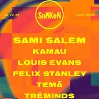
Sunken – 001 Opening Party ft Sami Salem – Mondays at Hazy
Sheffield's Biggest Monday Student Night Returns It's finally time to reunite under the lights of Tank the wait is over.

Event
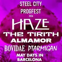
Steel City Progfest
Some Great Prog Rock Acts in one Fab All-Dayer In Sheffield headlined by Legendary Local Prog Rock Band, Haze!!


Event
Drake Night @ NETWORK
Join us at Network Sheffield on Saturday 19th of September for 'Drake Night'.


Event
Network Presents: Comedy @ Earl’s Yard
For everyone. No gate kept, no pretension. Just good comedy on a Sunday afternoon.

Event
The Meffs – Instore
The Meffs come to Sheffield for a special Album Launch Show at Arundel Emporium

Event
F*CK ME It’s Freshers – Sheffield
Originating at the 3000 capacity Coronet in London back in 2008, F*CK ME IT'S FRESHERS is an annual tradition for all new students starting university

Event
Sunken – 002 ft Rio Mercier – Mondays at Hazy
Sheffield's biggest Monday student night returns! It's finally time to reunite under the lights of Tank the wait is over.

Event
Bad Silence | Masha Jana | Rural City | Plasticine
Arundel Emporium bringing the best from the Steel City to the Stage.

Event
F*CK ME It’s Freshers – Sheffield
Originating at the 3000 capacity Coronet in London back in 2008, F*CK ME IT'S FRESHERS is an annual tradition for all new students starting university
Businesses and places
Showing 12 of 15.
Place
The Moor Market
Place
Networks
Place
Arundel Emporium
Place
Hazy Club Sheffield
Place
Network
Place
Network Sheffield
Place
The Moor
Place
Earls Yard
Place
Network 3
Place
Network 2
Charities based here
Charity
Friends of Sheffield Service for Sensory Impaired Children
Provide support to children with a hearing or visual impairment.
Charity
Causeway Charitable Services
Causeway supports marginalised and vulnerable people to recover from trauma and develop safe and fulfilling futures. Our modern slavery and crime reduction services include safe houses,…
Charity
Stroke Research and Community Support
Charity Shop City Centre SheffieldCharity Shop Knifesmithgate Chesterfield

Charity
Men Up North
TO PROMOTE AND PROTECT THE MENTAL HEALTH OF MEN AND BOYS IN THE NORTH OF ENGLAND THROUGH SUPPORT, PRACTICAL ADVICE AND NATURE CONNECTION ACTIVITIES IN PARTICULAR,…
NHS services here
GP practices, pharmacies and dentists whose postcode centre is inside this boundary, from the NHS organisation register. For urgent help call 999 or 111.
- Pharmacy Boots 66 the Moor, Sheffield S1 4PA
Landmarks and heritage
2 listed buildings, landmarks and plaques whose recorded position is inside this boundary, from Wikidata and Open Plaques.
- Landmark Moorfoot Building Architectural structure large office building in Sheffield, South Yorkshire, England Wikipedia · Photo on Commons
- Landmark Velocity Tower Tower block · since 2009 tower block in Sheffield, South Yorkshire, England, UK Wikipedia · Photo on Commons


Ofcom Connected Nations 2025
Broadband and mobile in The Moor
283 premises in 1 census output area whose population centre falls inside this boundary, as reported to Ofcom for July 2025.
Fixed broadband availability
- Gigabit-capable
- 38% Sheffield 93%
- 300 Mbit/s or faster
- 38% Sheffield 94%
- Superfast (30 Mbit/s or faster)
- 38% Sheffield 98%
- Cannot get 10 Mbit/s
- 0% Sheffield 0%
- Below the broadband USO
- 0% Sheffield 0%
Mobile signal
Mobile coverage is published for Sheffield as a whole: outdoor 4G from all four operators reaches 99.8% of premises, 5G from at least one operator 99.7%, and a good outdoor 4G or 5G signal from every operator 96.1%.
Availability means a service could be ordered at the address in July 2025; it is not a measured speed. Data edition: Ofcom Connected Nations 2025, published 19 November 2025.
Source: Ofcom Connected Nations 2025 data downloads (data for July 2025, published 19 November 2025), Ofcom copyright, reproduced under Ofcom's terms of use and the Open Government Licence v3.0. Output areas placed with ONS Open Geography lookups and population-weighted centroids, contains OS data © Crown copyright and database right 2026. Ofcom Connected Nations 2025 data · All data sources
Wildlife recorded here
1 dated observation inside this boundary in the last twelve months, from GBIF and iNaturalist. Each is a sighting on the day shown by the person credited; it is not a guarantee that the species is still there.
- Bird European Starling Sturnus vulgaris 12 Sep 2026 · Sue Murdoch · iNaturalist, CC BY 4.0
Homes and prices
What sold in The Moor
Only 1 standard sale was registered inside this boundary in the last twelve months, too few for a reliable local figure. Across Sheffield the median was £215,000.
Most recent registered sales
- Oct 2025 St Marys Gate Flat or maisonette, new build, leasehold £205,000
Contains HM Land Registry data © Crown copyright and database right 2026. This data is licensed under the Open Government Licence v3.0. Medians use standard sales only; the Land Registry’s additional category (for example buy-to-let and repossessions) is excluded. Data is published around a month in arrears and does not include every sale. Price Paid Data · All data sources
Census 2021
Who lives in The Moor
The Moor is smaller than a census area, so these figures describe the census area whose population centre is nearest to it (Sheffield 074A, 2,708 residents).
Ages
- Under 15
- 9% Sheffield 17%
- 15 to 24
- 54% Sheffield 16%
- 25 to 44
- 24% Sheffield 26%
- 45 to 64
- 9% Sheffield 24%
- 65 and over
- 3% Sheffield 17%
Homes
- Owned
- 10% Sheffield 59%
- Social rented
- 42% Sheffield 23%
- Private rented
- 48% Sheffield 19%
- One-person households
- 49% Sheffield 33%
- Detached
- 2% Sheffield 15%
- Semi-detached
- 7% Sheffield 38%
- Terraced
- 10% Sheffield 26%
- Flats
- 81% Sheffield 21%
Work and study, residents aged 16 and over
- In work
- 30% Sheffield 53%
- Full-time students
- 64% Sheffield 14%
- Retired
- 3% Sheffield 20%
- Unemployed
- 10% Sheffield 4%
Source: Office for National Statistics licensed under the Open Government Licence v.3.0. Census 2021 tables via Nomis; population-weighted centroids from ONS Open Geography, contains OS data © Crown copyright and database right 2026. Census 2021 on Nomis · All data sources
In numbers
The Moor in numbers
The same census and Land Registry figures shown above, drawn so the shape is easier to see, and set against every other Sheffield neighbourhood. Hover or tab to a bar for its value; every chart has its data as a table.
Ages
Homes
| Area | Owned | Social rented | Private rented |
|---|---|---|---|
| The Moor | 9.5% | 42.2% | 48.3% |
| Sheffield | 58.6% | 22.6% | 18.8% |
| Area | Detached | Semi-detached | Terraced | Flats |
|---|---|---|---|---|
| The Moor | 2% | 7% | 9.9% | 81.1% |
| Sheffield | 15% | 38% | 26% | 21% |
Sold prices by month
Only 1 sale was registered inside The Moor in the last twelve months; the monthly chart needs at least 12.
How this neighbourhood compares
The Moor is smaller than a census area, so it borrows a neighbour’s figures and is left out of the comparisons rather than counted twice.
Source: Office for National Statistics licensed under the Open Government Licence v.3.0. Census 2021 tables via Nomis; population-weighted centroids from ONS Open Geography, contains OS data © Crown copyright and database right 2026. Contains HM Land Registry data © Crown copyright and database right 2026. This data is licensed under the Open Government Licence v3.0. All data sources
Neighbouring areas
- Little Sheffield 7
- Devonshire Quarter 62
- Cultural Industries Quarter 149
- Highfield 49
- City Centre 302
- Broomhall 17
- Sharrow 20
Neighbourhood boundaries by Data for Action, licensed CC BY 4.0 and used with credit. Snapshot 946d748, published 16 Dec 2025, last checked 13 Sep 2026. Records are placed by their stored coordinates; a point on a shared boundary belongs to the first neighbourhood in the source file. All data sources