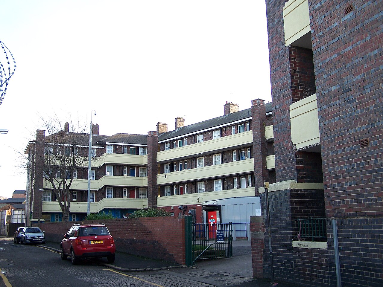
Photograph: Terry Robinson, CC BY-SA 2.0
All Sheffield areas · Open on the neighbourhood map
Sheffield neighbourhood
Kelham, Sheffield
Inside the Kelham boundary: 5 upcoming events, 7 businesses, 3 places, 7 charities.
Also known as Kelham Island.
Kelham Island is the former industrial district on the River Don just north of the city centre, now known for Kelham Island Museum, its breweries and beer pubs, independent food and the warehouse venues shared with neighbouring Neepsend. Christmas and food markets use the museum yard and the cobbled streets around Alma Street and Ball Street.
Coming up in this neighbourhood

Event
Sheffield Winter Book Fair
Northodox Press hosts its first festive independent book fair in Sheffield, featuring northern independent publishers. Free entry.

Event
Sheffield Record Fair at The Mowbray
AA Record Fairs record fair at The Mowbray in Neepsend with vinyl and CD dealers.
Event
Victorian Christmas Market at Kelham Island Museum
Over 80 stalls of Sheffield made wares and seasonal gifts under the gaslamps, with food and drink, brass bands and carollers, children's fairground rides, walkabout characters…

Event
The Festive Festival at The Mowbray
A candlelit Christmas market across The Mowbray and Victoria with Sheffield makers, creators and curators, choirs, festive food and drink and a mulled wine and mince…
Event
Victorian Christmas Market at Kelham Island Museum
Over 80 stalls of Sheffield made wares and seasonal gifts under the gaslamps, with food and drink, brass bands and carollers, children's fairground rides, walkabout characters…
Businesses and places
Place
Kelham Island Museum
Place
Riverside Kelham
Place
Only Clay
Place
Northodox Press
Place
The Mowbray
Place
Kelham Island Museum
Place
The Fat Cat
Place
The Ship Inn
Charities based here
Charity
Combustion Institute (British Section)
We are the British Section of the Combustion Institute. The Combustion Institute is an International Learned Society whose purpose is to promote and disseminate research into…
Charity
Ken Hawley Collection Trust
The Trust was created to acquire and safeguard, for the nation, a unique collection covering the range of Sheffield manufactures: edge tools, cutlery and flatware, silver,…
Charity
City Life International Church
THE PRINCIPAL ACTIVITY OF THE CHARITY IS THE ADVANCEMENT OF THE CHRISTIAN FAITH AND THE PRACTICAL OUTWORKING OF THAT FAITH IN THE LOCAL COMMUNITY OF SHEFFIELD,…
Charity
Tosalisana Congolese Community of Sheffield
Tosalisana C. C. S. is a non partisan organisation that seeks to support the self development and self advocacy of British African people in general, British…
Charity
Upper Don Trail Trust
Developing a 23km walking, cycling and riding route from the centre of Sheffield out to the Peak District
Charity
The Kelham Island and Neepsend Community Alliance
KINCA is a project-based city centre community organisation that runs a wide variety of projects to encourage social inclusion – from farmers markets to river clean-ups,…
Scorecard 1 card
How Kelham scores
Overall 54 out of 100, ranked 59 of 147 neighbourhoods, from 5 of 7 dimensions. Each score is a percentile rank against the other neighbourhoods, not a measurement.
- 46Quiet 3 inputs
- 28Green 3 inputs
- 68Connected 4 inputs
- 45Affordable 2 inputs
- –Safe not scored
- –Lively not scored
- 81Served 5 inputs
How these scores are worked out
Each input is a percentile rank: the share of the other neighbourhoods this one is at least as good as (direction per input). A dimension is the percentile rank of the mean of its available input ranks and needs at least two inputs; the overall score is the mean of the scored dimensions. Points are placed by point-in-polygon against the Data for Action boundaries; per-head figures use Census 2021 residents for neighbourhoods with their own census areas; noise shares sample an even grid of points inside each polygon against the Defra Lden bands; distances are straight lines from the polygon centre. Kelham covers 0.18 km² and borrows its census figures from the nearest census area, so per-head inputs are not ranked; noise was sampled at 94 points.
| Dimension | Input | Value | Rank | Better | Source | Licence |
|---|---|---|---|---|---|---|
| Quiet | Sampled points inside a Defra road-noise band (55 dB Lden and over) | 10.6% | 18 | lower | noise | Open Government Licence v3.0 |
| Quiet | Sampled points inside a Defra rail-noise band (55 dB Lden and over) | 0.0% | 100 | lower | noise | Open Government Licence v3.0 |
| Quiet | Daily vehicles at DfT count points inside the boundary (sum of AADT; 0 when no counted major road is inside) | 0 vehicles a day | 100 | lower | roads | Open Government Licence v3.0 |
| Green | Nature and green sites inside the boundary: Natural England reserves, SSSIs, ancient woodland and open access land, plus council historic parks | 0 per km² | 49 | higher | land, council_more | Open Government Licence v3.0 |
| Green | Council community-forestry trees planted inside the boundary | 0 per km² | 43 | higher | council_more | Open Government Licence v3.0 |
| Green | Recent wildlife observations inside the boundary (iNaturalist and GBIF; counts only) | 0 per km² | 75 | higher | nature | Per record: CC0, CC BY or CC BY-NC |
| Green | Playgrounds, sports pitches and dog parks on OpenStreetMap | – No own census population (figures for this neighbourhood are borrowed from the nearest census area). | – | higher | osm_amenities | ODbL 1.0 |
| Connected | NaPTAN bus and coach stops inside the boundary | 17.05 per km² | 45 | higher | naptan | Open Government Licence v3.0 |
| Connected | NaPTAN bus and coach stops inside the boundary | – No own census population (figures for this neighbourhood are borrowed from the nearest census area). | – | higher | naptan | Open Government Licence v3.0 |
| Connected | Straight-line distance from the neighbourhood centre to the nearest tram stop | 341 m | 88 | lower | naptan | Open Government Licence v3.0 |
| Connected | Straight-line distance from the neighbourhood centre to the nearest rail station entrance | 1,358 m | 85 | lower | naptan | Open Government Licence v3.0 |
| Connected | Premises able to get gigabit broadband (Ofcom Connected Nations) | 80.9% | 17 | higher | connectivity | Open Government Licence v3.0 |
| Affordable | Median sold price over the last twelve months (standard sales, at least five) | £171,000 | 64 | lower | pricepaid | Open Government Licence v3.0 |
| Affordable | Median sold price against the Sheffield median for the same mix of property types (1.0 = Sheffield) | 1.22 | 27 | lower | pricepaid | Open Government Licence v3.0 |
| Affordable | Median sold price of a terraced house (at least five sales) | – Fewer than five sales in the window. | – | lower | pricepaid | Open Government Licence v3.0 |
| Affordable | Households renting (council, other social and private), Census 2021, as a proxy for rented supply | – Figures for this neighbourhood are borrowed from a neighbour, so it is not ranked on them. | – | higher | census_more | Open Government Licence v3.0 |
| Safe | Recorded street-level crimes over the last twelve months | – No street-level crime rows are stored. | – | lower | police | Open Government Licence v3.0 |
| Safe | Violence and sexual offences over the last twelve months | – No street-level crime rows are stored. | – | lower | police | Open Government Licence v3.0 |
| Safe | Burglaries over the last twelve months | – No street-level crime rows are stored. | – | lower | police | Open Government Licence v3.0 |
| Safe | Anti-social behaviour reports over the last twelve months | – No street-level crime rows are stored. | – | lower | police | Open Government Licence v3.0 |
| Safe | The stored police data holds neighbourhood meetings and priorities only; street-level crime counts are deliberately not stored, so no neighbourhood has a safety score yet. | |||||
| Lively | Upcoming events and classes on Sheffield Events located inside the boundary | – No own census population (figures for this neighbourhood are borrowed from the nearest census area). | – | higher | neighbourhoods | CC BY 4.0 (Sheffield Events listings inside Data for Action boundaries) |
| Lively | Businesses and places in the Sheffield Events directory located inside the boundary | – No own census population (figures for this neighbourhood are borrowed from the nearest census area). | – | higher | neighbourhoods | CC BY 4.0 (Sheffield Events listings inside Data for Action boundaries) |
| Lively | Real ale pubs on OpenStreetMap | – No own census population (figures for this neighbourhood are borrowed from the nearest census area). | – | higher | osm_amenities | ODbL 1.0 |
| Lively | Community centres on OpenStreetMap | – No own census population (figures for this neighbourhood are borrowed from the nearest census area). | – | higher | osm_amenities | ODbL 1.0 |
| Served | Straight-line distance from the neighbourhood centre to the nearest GP practice (NHS ODS) | 839 m | 25 | lower | nhs | Open Government Licence v3.0 |
| Served | Community pharmacies inside the boundary (NHS ODS) | – No own census population (figures for this neighbourhood are borrowed from the nearest census area). | – | higher | nhs | Open Government Licence v3.0 |
| Served | Open primary and all-through schools inside the boundary (Get Information about Schools) | – No own census population (figures for this neighbourhood are borrowed from the nearest census area). | – | higher | schools | Open Government Licence v3.0 |
| Served | Straight-line distance from the neighbourhood centre to the nearest library (Sheffield City Council) | 986 m | 51 | lower | council | Open Government Licence v3.0 |
| Served | Public defibrillators on OpenStreetMap inside the boundary | 11.36 per km² | 95 | higher | osm_amenities | ODbL 1.0 |
| Served | Public toilets inside the boundary (OpenStreetMap and the Toilet Map) | 22.73 per km² | 99 | higher | osm_amenities | ODbL 1.0 and CC BY 4.0 |
| Served | Electric vehicle chargers on OpenStreetMap inside the boundary | 0 per km² | 86 | higher | osm_amenities | ODbL 1.0 |
Areas like this
- Norwood 54
- Gleadless Townend 43
- Walkley 48
- The Moor 65
- Broomhill 59
Neighbourhood scorecards by Sheffield Events, CC BY 4.0, derived from Defra noise mapping, DfT traffic counts, Natural England, Sheffield City Council, iNaturalist and GBIF, OpenStreetMap contributors (ODbL), the Toilet Map, NaPTAN, Ofcom, HM Land Registry, ONS Census 2021, NHS ODS, Get Information about Schools and the Data for Action neighbourhood boundaries; each input keeps its own licence. CC BY 4.0 · All data sources · Download the scores (API)
Living here 5 cards
Census 2021
How people here live
Kelham is smaller than a census area, so these figures describe the census area whose population centre is nearest to it (Sheffield 073C).
- Most common way to work
- Working from home 41.9% Sheffield Driving 45.2%
- Owner-occupied homes
- 17.3% Sheffield 58.6%
- Households without a car
- 45.8% Sheffield 29.2%
- Born outside the UK
- 38.3% Sheffield 14.9%
- Most common answer on religion
- No religion 51.1% Sheffield No religion 43.4%
- Degree-level qualified, 16 and over
- 63.3% Sheffield 33.4%
- In very good health
- 58.5% Sheffield 46.7%
Source: Office for National Statistics, Census 2021, via Nomis, Open Government Licence v3.0. Neighbourhood figures sum the census areas whose population-weighted centres (ONS Open Geography, contains OS data © Crown copyright and database right 2026) fall inside each boundary. Census 2021 on Nomis · All data sources
Deprivation here
1 small area (LSOA) has its population centre inside this boundary; its average IMD 2019 decile is 6.0 (1 is most deprived, 10 least).
Deprivation: English Indices of Deprivation 2019 by LSOA (MHCLG) with ONS population-weighted centroids, Open Government Licence v3.0. Decile 1 is the most deprived tenth of England. Indices of Deprivation 2019 · ONS Open Geography Portal · All data sources
Ofcom Connected Nations 2025
Broadband and mobile in Kelham
1,956 premises in 7 census output areas whose population centres fall inside this boundary, as reported to Ofcom for July 2025.
Fixed broadband availability
- Gigabit-capable
- 81% Sheffield 93%
- 300 Mbit/s or faster
- 81% Sheffield 94%
- Superfast (30 Mbit/s or faster)
- 90% Sheffield 98%
- Cannot get 10 Mbit/s
- 10% Sheffield 0%
- Below the broadband USO
- 0% Sheffield 0%
Mobile signal
Mobile coverage is published for Sheffield as a whole: outdoor 4G from all four operators reaches 99.8% of premises, 5G from at least one operator 99.7%, and a good outdoor 4G or 5G signal from every operator 96.1%.
Availability means a service could be ordered at the address in July 2025; it is not a measured speed. Data edition: Ofcom Connected Nations 2025, published 19 November 2025.
Source: Ofcom Connected Nations 2025 data downloads (data for July 2025, published 19 November 2025), Ofcom copyright, reproduced under Ofcom's terms of use and the Open Government Licence v3.0. Output areas placed with ONS Open Geography lookups and population-weighted centroids, contains OS data © Crown copyright and database right 2026. Ofcom Connected Nations 2025 data · All data sources
Homes and prices
What sold in Kelham
Completed sales registered from 27 Oct 2025 to 28 Aug 2026. 14 standard sales inside this boundary.
- Median price
- £171,000
- Middle half of sales
- £132,500 to £243,750
- Sheffield median
- £215,000
- Flat or maisonette
- £171,000 14 sales
Most recent registered sales
- Jul 2026 Green Lane Flat or maisonette, leasehold £356,000
- Jun 2026 Green Lane Flat or maisonette, leasehold £132,000
- May 2026 Kelham Island Flat or maisonette, leasehold £130,000
- May 2026 Cotton Street Flat or maisonette, leasehold £134,000
- Mar 2026 Green Lane Flat or maisonette, leasehold £305,000
- Feb 2026 Kelham Island Flat or maisonette, leasehold £210,000
- Feb 2026 Green Lane Flat or maisonette, leasehold £165,000
- Dec 2025 Dun Street Flat or maisonette, leasehold £120,000
Contains HM Land Registry data © Crown copyright and database right 2026. This data is licensed under the Open Government Licence v3.0. Medians use standard sales only; the Land Registry’s additional category (for example buy-to-let and repossessions) is excluded. These are actual registered sales, not the mix-adjusted UK House Price Index estimate. Data is published one to two months in arrears and does not include every sale. Checked 25 Oct 2026. Price Paid Data · All data sources
Census 2021
Who lives in Kelham
Kelham is smaller than a census area, so these figures describe the census area whose population centre is nearest to it (Sheffield 073C, 2,103 residents).
Ages
- Under 15
- 11% Sheffield 17%
- 15 to 24
- 31% Sheffield 16%
- 25 to 44
- 49% Sheffield 26%
- 45 to 64
- 8% Sheffield 24%
- 65 and over
- 2% Sheffield 17%
Homes
- Owned
- 17% Sheffield 59%
- Social rented
- 18% Sheffield 23%
- Private rented
- 65% Sheffield 19%
- One-person households
- 50% Sheffield 33%
- Detached
- 1% Sheffield 15%
- Semi-detached
- 4% Sheffield 38%
- Terraced
- 5% Sheffield 26%
- Flats
- 89% Sheffield 21%
Work and study, residents aged 16 and over
- In work
- 61% Sheffield 53%
- Full-time students
- 29% Sheffield 14%
- Retired
- 2% Sheffield 20%
- Unemployed
- 6% Sheffield 4%
Source: Office for National Statistics licensed under the Open Government Licence v.3.0. Census 2021 tables via Nomis; population-weighted centroids from ONS Open Geography, contains OS data © Crown copyright and database right 2026. Census 2021 on Nomis · All data sources
Getting around 2 cards
Department for Transport STATS19
Road collisions here, 2021 to 2025
6 road collisions with someone hurt were recorded in this neighbourhood, 2021 to 2025: 0 fatal, 2 serious and 4 slight. 2 pedestrians and 2 cyclists were among the 6 people hurt.
- Collisions
- 6
- Fatal
- 0
- Serious
- 2
- Slight
- 4
- People hurt
- 6
- Pedestrians hurt
- 2
- Cyclists hurt
- 2
- 2021: 0 fatal, 1 serious, 1 slight2 hurt (pedestrians 1, cyclists 1)
- 2023: 0 fatal, 1 serious, 0 slight1 hurt (pedestrians 0, cyclists 0)
- 2024: 0 fatal, 0 serious, 3 slight3 hurt (pedestrians 1, cyclists 1)
Road collisions across Sheffield · On the Local Map
Road collision data from the Department for Transport (STATS19 road safety open data), Open Government Licence v3.0 Open Government Licence v3.0. Checked 12 Oct 2026. Road safety open data · All data sources
National Cycle Network
Signed cycle routes here
1.3 km of the National Cycle Network pass through this neighbourhood (Route 627).
- 3 segments Route 6271.3 km in Sheffield · 56% traffic-free · 100% lit · mostly block paving, asphalt
National Cycle Network data from the Walk Wheel Cycle Trust (formerly Sustrans) under the Open Government Licence v3.0. Contains Ordnance Survey data © Crown copyright and database rights 2018. Open Government Licence v3.0. Checked 26 Oct 2026. The dataset on ArcGIS · All data sources
Environment and sky 7 cards
Noise here
About 9% of this area is mapped at 55 dB or more from road traffic; the loudest band here is 70 to 75 dB, covering about 7%.
Rain and rivers here
Nearest rain gauge: Ringinglow, 6.2 km away. 59.6 mm of rain in the last 7 days, wettest day Saturday 24 Oct with 27.3 mm.
Air quality here
No sensor inside this boundary; the nearest is shown.
- Within WHO guideline Sensor 68956 PM2.5 3.3, PM10 10.1 µg/m³ · 2.2 km from the centre of the area · read 29 Oct 06:24
British Geological Survey
The ground beneath Kelham
At the centre of Kelham the bedrock is the Pennine Lower Coal Measures Formation: mudstone, siltstone, sandstone, coal, ironstone and ferricrete, Carboniferous, Langsettian (Westphalian A), about 316 to 314 million years ago, on the BGS 1:625 000 bedrock map (unit PSLCM). The 1:625 000 map is a regional overview generalised from more detailed sheets: it describes the ground under a neighbourhood as a whole and is not a site investigation.
Contains British Geological Survey materials © UKRI 2026. Open Government Licence v3.0. Checked 10 Oct 2026. BGS Geology 625k bedrock · All data sources
Recorded flood outlines
Floods recorded here
The Environment Agency has mapped 4 floods reaching part of Kelham / Kelham Island, the earliest in 2000. The outlines show where water got to those times, not where it will go next, and floods that nobody surveyed are not recorded.
- 2022 February Flood Incident – Storm Dudley, Eunice and Franklin20 Feb to 28 Mar 2022 · 1 outline · main river · overtopping of defences
- 2019 November Flood Incident7 to 8 Nov 2019 · 1 outline · main river · channel capacity exceeded
- 2007 River Don – Wadlesy Bridge to Philadelphia15 to 30 Jun 2007 · 1 outline · main river · channel capacity exceeded
- Autumn 20006 Nov to 4 Dec 2000 · 2 outlines · main river
The outlines on the Local Map · Today's river levels
Recorded Flood Outlines, © Environment Agency copyright and/or database right 2025. Open Government Licence v3.0. Checked 12 Oct 2026. Recorded Flood Outlines dataset · All data sources
Mining Remediation Authority
Coal mining legacy here
About 53.6% of Kelham / Kelham Island, roughly 9.2 hectares, lies in a coal mining Development High Risk Area: recorded shafts, adits or shallow workings are at or near the surface, so new building there needs a coal mining risk assessment.
- Land in a high risk area
- 53.6%about 9.2 hectares
- Sheffield as a whole
- 17.1%
This is a planning designation drawn from recorded features, not a survey of any one property, and being in an area does not mean the ground there is unsafe. Buying or building? Ask the authority itself. Check if a property is affected by coal mining · Coal mining risk assessments for planning · Report a coal mine hazard (24 hours)
Contains Mining Remediation Authority data, Crown copyright, Open Government Licence v3.0. Checked 26 Oct 2026. Dataset: Coal mining Development High Risk Area · All data sources
Benches and geocaches here
1 memorial bench with its inscription from OpenBenches, at recorded positions inside this boundary.
- Bench THIS BENCH IS DEDICATED TO THE MEMORY OF Ronald Garfoot Marshall 1934 – 2009 HIG… THIS BENCH IS DEDICATED TO THE MEMORY OF Ronald Garfoot Marshall 1934 – 2009 HIGHLAND LIGHT INFANTRY 1952 – 1959 SHEFFI… recorded Apr 2026
Heritage and culture 3 cards
On Wikipedia and Commons
6 Wikipedia articles and 14 freely licensed photos on Wikimedia Commons, placed inside this boundary.
- Kelham Island Brewery The Kelham Island Brewery was a small independent brewery based in the Kelham Island Quarter area of Sheffield, South Yorkshire, England.
- Kelham Island Museum The Kelham Island Museum is an industrial museum on Alma Street, alongside the River Don, in the centre of Sheffield, England.
- River Don Engine The River Don Engine is a 1904-built steam engine used for hot rolling steel armour plate.
- Brooklyn Works
- Green Lane Works
- Kelham Island Tavern


Landmarks and heritage
13 listed buildings, landmarks and plaques whose recorded position is inside this boundary, from Wikidata and Open Plaques.
- Listed or scheduled Entrance Gateway to Green Lane Works Grade II* listed building gateway in Sheffield, South Yorkshire, England, UK Photo on Commons · Heritage List entry
- Listed or scheduled Brooklyn Works Grade II listed building architectural structure in Sheffield, South Yorkshire, England, UK Wikipedia · Photo on Commons · Heritage List entry
- Listed or scheduled Crucible Workshop At Former Williams Brothers Grade II listed building architectural structure in Sheffield, South Yorkshire, England, UK Heritage List entry
- Listed or scheduled Former Russell Works, (Now Part Of Kelham Island Industrial Museum) Grade II listed building museum building in Sheffield, South Yorkshire, England, UK Heritage List entry
- Listed or scheduled Kelham Weir Grade II listed building weir near Ball Street Bridge in Sheffield, South Yorkshire, England, UK Photo on Commons · Heritage List entry
- Listed or scheduled The Fat Cat Grade II listed building · since 1850 pub in Sheffield, South Yorkshire, England, UK Photo on Commons · Heritage List entry
- Listed or scheduled William Brothers Of Sheffield Grade II listed building architectural structure in Sheffield, South Yorkshire, England, UK Heritage List entry
- Landmark Green Lane Works Building building in Sheffield, South Yorkshire, England, UK Wikipedia · Photo on Commons
- Landmark Kelham Island Museum Independent museum museum in Sheffield, England Wikipedia · Photo on Commons
- Landmark Kelham Island Tavern Pub public house in Sheffield, England Wikipedia · Photo on Commons
- Plaque Bessemer Converter grey plaque Grey plaque · Bessemer Converter · erected 2004 The Bessemer Converter In recognition of the outstanding contribution to the steel industry by Sir Henry Bessemer through his invention of the Bessemer Process for steelmaking as embodied in this last remaining example o… Open Plaques record
- Plaque Blue plaque № 8975 Blue plaque · erected 1985 River Don Engine A three-cylinder 12,000hp engine with Joy Valve Gear, one of the most powerful surviving steam engines in the world. Built in 1905 by Davy Brothers of Sheffield, and installed at Cammell's Grimesthorpe W… Open Plaques record
- Plaque Grey plaque № 8940 Grey plaque · erected 2005 Bramah Hydraulic Press Presented in recognition of the outstanding contribution to mechanical engineering made by Joseph Bramah in laying the foundations of fluid power engineering, as embodied in this last remaining exa… Open Plaques record


Museums and galleries here
2 museums and galleries inside this boundary.
- Kelham Island Museum Independent museum · Sheffield Museums Trust · step-free
- Ken Hawley Collection free admission
Council and democracy 4 cards
Council data for this area
What Sheffield City Council's open data records inside this boundary.
- 20 mph zone City Centre Phase 2 CC2
- Local heritage Former workhouse and cotton mill buildings, Alma Street
- Polling station City Life Church 1 South Parade S3 8SS City Ward · district GE
- Litter bins 11 council litter bins on the streets here
Planning applications here
9 applications lodged in the last 12 weeks, 6 still undecided.
- Undecided180 Shalesmoor Sheffield S3 8RG
- UndecidedAircraft & Commercial Tools Ltd Bowling Green Street Sheffield S3 8SU
- UndecidedW2 Green Lane Works Green Lane Shalesmoor Sheffield S3 8DX
- Undecided180 Shalesmoor Sheffield S3 8RG
- UndecidedAvis Budget Acorn Street Sheffield S3 8UR
- ConditionsAircraft & Commercial Tools Ltd Bowling Green Street Sheffield S3 8SU
- UndecidedAvis Budget Acorn Street Sheffield S3 8UR
- PermittedBuilding Between Cotton Street And 24 Alma Street Sheffield S3 8SA
- All 9 applications on the map
Planning applications: UK PlanIt, aggregated from Sheffield City Council. Check the council record before relying on any detail; documents are linked, never copied. UK PlanIt · All data sources
Planning constraints
Conservation areas and brownfield land here
2 conservation areas cover part or all of this neighbourhood, so changes to buildings, trees and frontages there need extra care and often permission. 9 sites on the brownfield land register sit here, 4.3 hectares in all put forward for housing.
- Land And Buildings at Kelham Riverside, Alma Street And Green Lane
- Site of 55 Russell Street and Bowling Green Street Sheff. S3 8RW
- (Kelham Central) Site of Richardsons Cutlery Works, 60 Russell Street, Cotton Street and Alma Street, Sheffield S3 8RW
- Site At 31 Acorn Street/Dunfields/Green Lane (Site 4), Sheffield, S3 8SQ
- Cotton Mill Road
- Land Between Cotton Mill Row, Cotton Street And Alma Street Sheffield S3 4RD
- Site Of 55 Russell Street And Bowling Green Street Sheffield S3 8RW
- Carr Motors Ltd 318-328 Shalesmoor Sheffield S3 8UL
- And 1 more on the register. Brownfield land across Sheffield
Contains planning.data.gov.uk data published by Sheffield City Council and neighbouring planning authorities under the Open Government Licence v3.0; conservation area boundaries © Historic England, containing Ordnance Survey data © Crown copyright and database right. Open Government Licence v3.0. Checked 10 Oct 2026. planning.data.gov.uk · All data sources
Draft Sheffield Plan
Sites the plan allocates here
7 sites in this neighbourhood are allocated in the draft Sheffield Plan, with room for 568 new homes in all. It is a draft at Main Modifications stage with a further round of changes still to settle, so sites and numbers can change. About the Sheffield Plan
- KN04 Land at Russell Street and Bowling Green Street, S3 8UHStrategic Housing Site · 200 homes · 0.86 ha · brownfield
- KN09 Buildings at Shalesmoor and Cotton Mill Road, S3 8RGHousing Site · 118 homes · 0.26 ha · brownfield
- KN23 Buildings at South Parade, Bowling Green Street and Ward Street, S3 8SRHousing Site · 100 homes · 0.13 ha · brownfield
- KN22 Moorfields Flats, Shalesmoor and Ward Street, S3 8UHHousing Site · 50 homes · 0.16 ha · brownfield
- KN26 SIP Car Parks, Car Park At Junction With Bowling Green Street, Russell Street, S3 8SUHousing Site · 44 homes · 0.08 ha · brownfield
- KN32 Land at Acorn Street, S3 8URHousing Site · 43 homes · 0.10 ha · brownfield
- KN33 284 Shalesmoor, S3 8ULHousing Site · 13 homes · 0.07 ha · brownfield
Site allocations: Sheffield City Council, Main Modifications Sheffield Plan Policies Map, under the Open Government Licence v3.0. Contains Ordnance Survey data © Crown copyright and database right. Checked 12 Oct 2026. Dataset: Site Allocation · All data sources
Money and energy 3 cards
National Lottery grant database
Lottery money in City ward
Awards filed to recipients in City ward, the ward this area sits in. Awards to individuals are counted in the figures and never named.
- Awards since 1995
- 1,504
- Awarded in total
- £227.0m
- Awards since 2022
- 262
- Awarded since 2022
- £37.7m
Latest awards to organisations here
- South Yorkshire Mayoral Combined Authority · £531,045South Yorkshire's People's Forest · The National Lottery Heritage Fund · 8 Sep 2026
- The Counselling and Therapy Hub CIC · £20,000Peer Support and Training for Neurodivergent Adults · National Lottery Awards for All England · The National Lottery Community Fund · 3 Sep 2026
- Roots Mbili Theatre · £250,000Theatre Breakthrough Fund (North) Stage Two Application · Theatre Breakthrough Fund (North) · Arts Council England · 27 Aug 2026
Lottery money across Sheffield
National Lottery grant data from the Department for Culture, Media and Sport, Open Government Licence v3.0. Checked 28 Oct 2026. National Lottery grant database · Sheffield export (CSV) · All data sources
Office for National Statistics via Nomis
Work in this area
Kelham sits in City (Sheffield) ward. The claimant count is the number of people there on Universal Credit or Jobseeker's Allowance who are required to look for work, as a share of residents aged 16 to 64; the ward series begins in January 2026.
- Claimants in City (Sheffield) ward
- 845Sep 2026
- Share of residents aged 16 to 64
- 3.1%Sep 2026
- Sheffield
- 4.4%16,785 claimants, Sep 2026
| Month | City (Sheffield) | Sheffield |
|---|---|---|
| Jan 2026 | 2.8 % | 4.2 % |
| Feb 2026 | 2.8 % | 4.3 % |
| Mar 2026 | 2.9 % | 4.3 % |
| Apr 2026 | 2.9 % | 4.3 % |
| May 2026 | 3 % | 4.3 % |
| Jun 2026 | 2.9 % | 4.3 % |
| Jul 2026 | 2.9 % | 4.3 % |
| Aug 2026 | 3.1 % | 4.3 % |
| Sep 2026 | 3.1 % | 4.4 % |
Source: Office for National Statistics licensed under the Open Government Licence v3.0, via Nomis. Ward boundaries from ONS Open Geography, OGL v3.0. Checked 26 Oct 2026. Claimant count on Nomis · Nomis · All data sources
Sheffield City Council business rates
Rated business premises here
268 premises in Kelham / Kelham Island are on the business rates list, with a combined rateable value of £2,589,830.
- Rated premises
- 268
- Total rateable value
- £2,589,830
- Middle rateable value
- £5,300
- Shops and retail
- 27
- Offices
- 69
- Workshops, warehouses and industry
- 119
- Pubs, restaurants, cafes and hotels
- 24
Commonest kinds
- Offices And Premises68 premises
- Workshop And Premises56 premises
- Business Unit And Premises26 premises
- Shop And Premises25 premises
- Store And Premises22 premises
Streets with the most premises
- Mowbray Street, S3127 rated premises
- Ball Street, S341 rated premises
- Shalesmoor, S334 rated premises
- Kelham Square, S311 rated premises
- Derek Dooley Way, S39 rated premises
- Alma Street, S37 rated premises
Highest rateable values here
- 1 Russell Street, S3 8RWWarehouse And Premises · rateable value £134,000 · rates paid by Safestore Trading Ltd
- 204 Shalesmoor, S3 8UHLeisure Centre And Premises · rateable value £95,000 · rates paid by The Gym Ltd
- Morriseys Riverside Inn, 1 Mowbray Street, S3 8ENPublic House And Premises · rateable value £87,500 · rates paid by True North Brew Co Ltd
- The Fat Cat, 23 Alma Street, S3 8SAPublic House And Premises · rateable value £61,000 · rates paid by The Fat Cat (Sheffield) Limited
- Tesco Express, Central Quay, S3 8RAShop And Premises · rateable value £55,000 · rates paid by Tesco Stores Ltd
Business premises across Sheffield · On the Local Map
Business rates public dataset from Sheffield City Council via Data Mill North, Open Government Licence v3. Checked 12 Oct 2026. Business rates on Data Mill North · All data sources
Sport and facilities 1 card
Somewhere to play here
1 site inside this boundary, with 1 facilities on it.
- The Gym Group (Sheffield Kelham Island) Health and Fitness Gym · Commercial
Community 1 card
Around here
41 everyday places mapped inside this boundary by OpenStreetMap volunteers and the Toilet Map.
- 13 public artworks
- 12 cycle parking stands
- 3 toilets on the Toilet Map
- 2 defibrillators
- 2 post boxes
- 2 real-ale and brewery pubs
- 1 cash machine
- 1 public bookcase
- 1 memorial
- 1 sports pitch
- 1 toilets
- 1 viewpoint
- 1 drinking water
- Nearest defibrillator Defibrillator 120 m away from the centre of the area
- Nearest toilets Toilets 60 m away from the centre of the area
- Nearest drinking water Drinking water 270 m away from the centre of the area
- Nearest cycle parking Cycle parking 40 m away from the centre of the area
- Nearest ev charger EV charger 790 m away from the centre of the area
Charts 1 card
In numbers
Kelham in numbers
The same census and Land Registry figures shown above, drawn so the shape is easier to see, and set against every other Sheffield neighbourhood. Hover or tab to a bar for its value; every chart has its data as a table.
Ages
Homes
| Area | Owned | Social rented | Private rented |
|---|---|---|---|
| Kelham | 17.3% | 18% | 64.7% |
| Sheffield | 58.6% | 22.6% | 18.8% |
| Area | Detached | Semi-detached | Terraced | Flats |
|---|---|---|---|---|
| Kelham | 0.9% | 4.4% | 5.5% | 89.2% |
| Sheffield | 15% | 38% | 26% | 21% |
Sold prices by month
Only 11 sales were registered inside Kelham in the last twelve months; the monthly chart needs at least 12.
| Area | Lower quartile | Median | Upper quartile | Sales |
|---|---|---|---|---|
| Kelham | £132,500 | £171,000 | £243,750 | 14 |
| Sheffield | £161,875 | £215,000 | £300,000 | 4,388 |
How this neighbourhood compares
Kelham is smaller than a census area, so it borrows a neighbour’s figures and is left out of the comparisons rather than counted twice.
Source: Office for National Statistics licensed under the Open Government Licence v.3.0. Census 2021 tables via Nomis; population-weighted centroids from ONS Open Geography, contains OS data © Crown copyright and database right 2026. Contains HM Land Registry data © Crown copyright and database right 2026. This data is licensed under the Open Government Licence v3.0. All data sources
More 2 cards
Recorded crime here, August 2026
10 offences were recorded inside this boundary in August 2026.
| Offence type | Recorded |
|---|---|
| Anti-social behaviour | 4 |
| Violence and sexual offences | 4 |
| Other theft | 2 |
Offences recorded by South Yorkshire Police in August 2026, counted into this neighbourhood. Locations published by the Home Office are approximate by design, so this is a count for the area, never for a street or an address.
Alerts
Follow Kelham / Kelham Island and hear what happens here: new events and places listed, planning applications, roadworks, storm overflows, floods and poor air. Floods and overflows arrive straight away; the rest come as one round-up at 8am, grouped by area.
Yorkshire Water (CC BY 4.0), Environment Agency (OGL v3), UK PlanIt and TomTom via the live map.
Kelham: your questions answered
What is on in Kelham soon?
5 upcoming events are located inside the Kelham boundary, starting with Sheffield Winter Book Fair (28 November), Sheffield Record Fair at The Mowbray (29 November), Victorian Christmas Market at Kelham Island Museum (5 December). Every listing has the venue, a map and the organiser's link.
Which venues and businesses are in Kelham?
10 directory entries sit inside Kelham, including Kelham Island Museum, Riverside Kelham, Only Clay, Kelham Island Artist Collective (KIAC), Gage Gallery, Kelham Island Artist Collective (KIAC). Each has its address, opening details where published and its upcoming events.
Which areas are next to Kelham?
The areas nearest to Kelham are Saint Vincent's and Shalesmoor, Neepsend, Wicker, Castlegate, Parkwood Springs. Each has its own page with the events and places inside it.
How is the Kelham boundary defined?
The boundary is the Kelham polygon from the Sheffield neighbourhoods dataset published by Data for Action, one of 147 across the city. Events, businesses, places and charities are placed inside it by their coordinates, so a venue just over the line appears on the neighbouring page instead.
Neighbouring areas
Neighbourhood boundaries by Data for Action, licensed CC BY 4.0 and used with credit. Snapshot 946d748, published 16 Dec 2025, last checked 13 Oct 2026. Records are placed by their stored coordinates; a point on a shared boundary belongs to the first neighbourhood in the source file. All data sources