28 August 2026 · 18:30 – 23:00
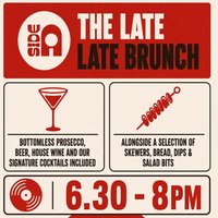
The Late Late Brunch
Side A Sheffield, Sheffield, S2 4QU
Get your Friday going with our brand new evening brunch. Bottomless drinks, skewers, breads & dips, great soundtrack. Limited places -bookings only!
Getting there and what to expect
Weather
- Sunset 20:05, dark from 20:42 (Sunset and dusk computed for the venue)
Getting there
- Stops: Bramall Lane/John Street (By) (121 m, 18 18A 73 252); Bramall Lane/Denby Street (adj) (148 m, 18 18A 73 252); London Road/Alderson Road (adj) (233 m, 20 43 44 75 76 76A) (Stops: NaPTAN, Department for Transport (OGL v3); lines: bustimes.org / Bus Open Data (OGL v3))
- Sheffield Rail Station 1.1 km away, tram at Granville Road 930 m away (Stops: NaPTAN, Department for Transport (OGL v3); lines: bustimes.org / Bus Open Data (OGL v3))
- Parking: New Era Square 170 m (OpenStreetMap contributors (ODbL))
- Cycle parking 50 m, EV charger 380 m (LifeEV) (OpenStreetMap contributors (ODbL))
- About 15 min walk from the city centre (1.2 km, straight-line estimate) (Straight-line estimate at 5 km/h; streets are longer)
- Open on the main map with this event pinned (Sheffield Events live map)
- Can I get there and back? Put your postcode into the tool below for the last bus and tram, the walk home, and the car parks. (Timetables: Bus Open Data Service (Department for Transport). Contains public sector information licensed under the Open Government Licence v3.0.)
Around the venue
- Air quality within WHO guideline (PM2.5 2.1, PM10 11.0 µg/m³, sensor 810 m away) (Air quality: Sensor.Community (ODbL, indicative) and DEFRA UK-AIR (OGL v3))
- Defibrillator 130 m, toilets 290 m (OpenStreetMap contributors (ODbL))
- No storm overflow discharging within 1 km (Storm overflows: Yorkshire Water (CC BY 4.0))
Can I get there and back
The last bus and tram, the walk, what is recorded about step-free access and the car parks.
- Nearest defibrillator Defibrillator 130 m away
- Nearest toilets Toilets 290 m away
- Nearest cycle parking Cycle parking 50 m away · 8 spaces
- Nearest EV charger LifeEV 380 m away
Read about this area on Wikipedia
- Portland Works
- Sheffield United F.C.
Sheffield United Football Club is a professional football club based in Sheffield, South Yorkshire, England.
- Bramall Lane
Bramall Lane is a football stadium in Sheffield, South Yorkshire, England, which is the home of Sheffield United.
- Highfield Cocoa and Coffee House
- St Mary's Church, Bramall Lane
St Mary's Church, Bramall Lane is a Church of England parish church in the City of Sheffield, England.
Article titles and extracts from Wikipedia, CC BY-SA 4.0; each links to its article.
- 252 to Sheffield Centre 0.3 km away, 5 min early
- 63 to Crystal Peaks 0.3 km away
- 1 to High Green 0.3 km away, 2 min late
- 1 to Jordanthorpe 0.4 km away, on time
Around the same time
Staying over?
Make a night of it – find a place to stay near Side A Sheffield, Sheffield, S2 4QU.
- DoubleTree by Hilton Sheffield City 217 m away
- Premier Inn Sheffield City Centre (St Mary’s Gate) 391 m away
- Leonardo Hotel Sheffield 751 m away
- Novotel Sheffield Centre 1.1 km away
- Mercure Sheffield St Paul’s Hotel and Spa 1.1 km away
Also at Side A Sheffield, Sheffield, S2 4QU
You might also like
Your event memories
Check in, add a photo and build your Sheffield journey.