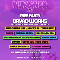
25 July 2026 · 18:00 – 00:00
Free Party At Dryad Works – WUBLINES 2026 – Arc Audio & Impulse
Dryad Works, Sheffield, S3 8AG
Free Party At Dryad Works – WUBLINES 2026 Powered by Arc Audio & Impulse Sound System. 6pm – Midnight. Garage / Bassline / Drum n Bass / 140’s & More
Getting there and what to expect
Weather
- Sunset 21:13, dark from 21:59 (Sunset and dusk computed for the venue)
Getting there
- Stops: Neepsend Lane/Hillfoot Road (adj) (328 m); Neepsend Lane/Hillfoot Road (opp) (337 m); Penistone Road/Club Mill Road (adj) (346 m) (Stops: NaPTAN, Department for Transport (OGL v3); lines: bustimes.org / Bus Open Data (OGL v3))
- Tram at Langsett/ Primrose 450 m away (Stops: NaPTAN, Department for Transport (OGL v3); lines: bustimes.org / Bus Open Data (OGL v3))
- Parking: Morrisons 900 m (OpenStreetMap contributors (ODbL))
- Cycle parking 480 m, EV charger 520 m (OpenStreetMap contributors (ODbL))
- About 26 min walk from the city centre (2.1 km, straight-line estimate) (Straight-line estimate at 5 km/h; streets are longer)
- Open on the main map with this event pinned (Sheffield Events live map)
- Can I get there and back? Put your postcode into the tool below for the last bus and tram, the walk home, and the car parks. (Timetables: Bus Open Data Service (Department for Transport). Contains public sector information licensed under the Open Government Licence v3.0.)
Around the venue
- Air quality within WHO guideline (PM2.5 0.6, PM10 3.6 µg/m³, sensor 1.9 km away) (Air quality: Sensor.Community (ODbL, indicative) and DEFRA UK-AIR (OGL v3))
- Defibrillator 310 m, toilets 880 m (OpenStreetMap contributors (ODbL))
- No storm overflow discharging within 1 km (Storm overflows: Yorkshire Water (CC BY 4.0))
Can I get there and back
The last bus and tram, the walk, what is recorded about step-free access and the car parks.
- Nearest defibrillator Defibrillator 310 m away · 24/7
- Nearest toilets Toilets 880 m away · free
- Nearest cycle parking Cycle parking 480 m away
- Nearest EV charger EV charger 520 m away · InstaVolt
Read about this area on Wikipedia
- Neepsend railway station
- Neepsend
- River Loxley
The River Loxley is a river in the City of Sheffield, South Yorkshire, England.
- Sheffield Ski Village
Sheffield Ski Village was an artificial ski slope complex in the Parkwood Springs area of Sheffield, England which operated from 1988 until it was destroyed by fire in 2012.
- Neepsend engine shed
Neepsend engine shed was an engine shed in Neepsend, Sheffield, South Yorkshire, England.
Article titles and extracts from Wikipedia, CC BY-SA 4.0; each links to its article.
- 7 to Ecclesfield 0.5 km away, 3 min late
- 31 to Parson Cross 0.7 km away, 3 min early
- H1 to Fir Vale 0.8 km away, 5 min late
- 82 to Stannington 1.0 km away, 2 min late
Around the same time
Staying over?
Make a night of it – find a place to stay near Dryad Works, Sheffield, S3 8AG.
- Nights Inn Bar and Rooms 1.9 km away
- Leopold Hotel Sheffield 2.0 km away
- Premier Inn Sheffield City Centre (Angel Street) 2.0 km away
- Crowne Plaza Royal Victoria Sheffield 2.1 km away
- Cutlers Hotel Sheffield 2.1 km away
Also at Dryad Works, Sheffield, S3 8AG
You might also like
Your event memories
Check in, add a photo and build your Sheffield journey.